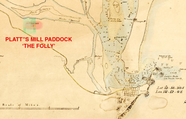
‘We arrived at a place then called The Folly now Waratah. The name given to an estate bought by a man named Charles Simpson, it was situated near the old Mill Padock which was a government grant to a man named Platt. He worked the place by government men who were convicts … We and 2 other family being first to settle at Waratah.’ 1
In the newspaper article relating George Abner Gray’s early memories of Waratah he states; “At the time there were no other settlers within miles. The first who came were in Mr Simpson’s interest. He had a brick house built and soon made wonderful improvements. The two sawyers who cut the necessary timber for the house were Ben Baker and Harry Crouthers, while the builder’s name was Gray. The gardener was Mr Bull the grandfather of Dick Tressider, the boat puller.” 2
This indicates that George Gray and Edmund Bull and their families, along with another family which is most likely to have been Ben Baker given the Baptismal information for the Baker’s children, were the first settlers at ‘The Folly’, Waratah. This is supported by the previous documentation.
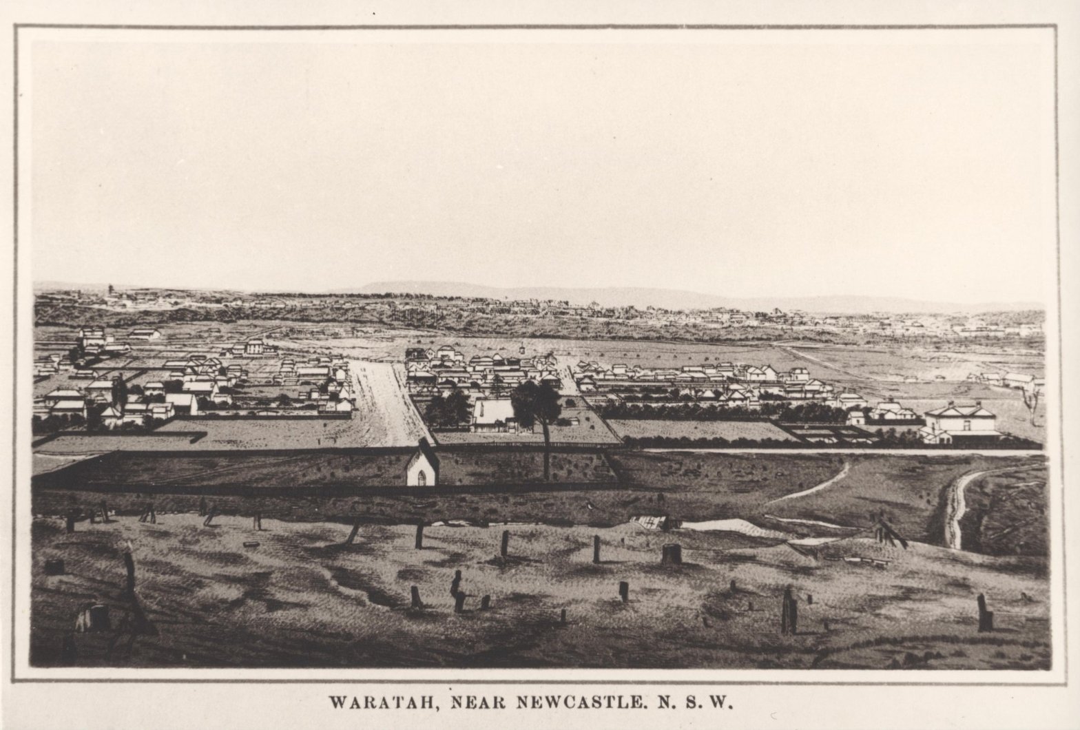
The Folly, where Waratah House was located is approximately an 8 ½ kilometres walk from the original main street of Newcastle. Today it would take about 1 ¾ hours to walk that distance, but back in the 1850’s when Charles Simpson, George Gray and Edmund Bull first settled at the allotment 50 and 51 land, it would have been bushland with perhaps some tracks. In 1936 the historian Thomas Braye described it has being covered in ‘dense tropical bush‘.3 In her account of early settlement Mabel Grierson, the daughter of Georgina Grierson nee Gray and George Gray’s granddaughter, recalls: ‘when the house [Waratah House] was built early settlers on The Folly who worked in Newcastle considered it “too far to go home to Mayfield” every night. To get there meant riding on horseback through trackless scrub or doing what Mr Simpson is said to have done – rowing up the river.’ 4 Edmund Bull’s son Sydney recalls: ‘Mayfield was a scrub of dense ti-tree that was more or less a swamp in winter.’ 5
In an address to the Newcastle & Hunter District Historical Society in 1935 T A Braye describes some of the flora: ‘on the southern bank of the South Channel of the Hunter River. Immediately behind the mangroves fringing the River there was a small belt of dense, tropical brush consisting of wild native figs, black apple trees, myrtle, cedar, and general brush growth.’ 6
Some of the flora of this area has been recorded by CSIRO researcher Petrus C. Heyligers in Flora of the Stockton and Port Hunter sandy foreshores with comments on fifteen notable introduced species.
John Laurio Platt – First settler Newcastle District
The original land owner for this region was John Laurio Platt born in Nottingham, England in 1782 coming to New South Wales on the ship the ‘Providence’ in 1821. His letter of introduction from the Under-secretary of Goulburn to the Governor of Brisbane May 25, 1821 stated: “This letter will be delivered to you by Mr John Platt who proceeds with his family to settle in New South Wales and proposes to erect sawmills and other machinery in the Colony. As Mr Platt has been for some years past employed under this Department on the Lakes in Canada, and as Harbour Master at Heligoland, and he has served not only with credit to himself but with advantage to the British Service, I have been directed by Lord Bathurst to introduce him more particularly to your notice and protection as having claims beyond those of an ordinary settler. Feb. 13th, 1821.” 7
Mitchell Library – New South Wales State Library
The Australian Dictionary of Biography has an outline of John Laurio Platt‘s life noting: ‘He was the first of the original grantees to settle on his estate, which he named Iron Bark Hill. There he erected a homestead and windmill. He had hoped to export sawn wood to England, having been encouraged by the dealers in fancy woods there, but no evidence survives that he succeeded in doing so. He infringed the Australian Agricultural Co.’s monopoly by mining coal and shipping it on barges.
His affairs generally did not prosper. He suffered from chronic asthma. In 1831 his homestead was burnt down and two of his sons died in the fire. He built a new homestead on the road to Maitland, and tried to sell the estate but it needed development and he could not afford to make it profitable.’ 8
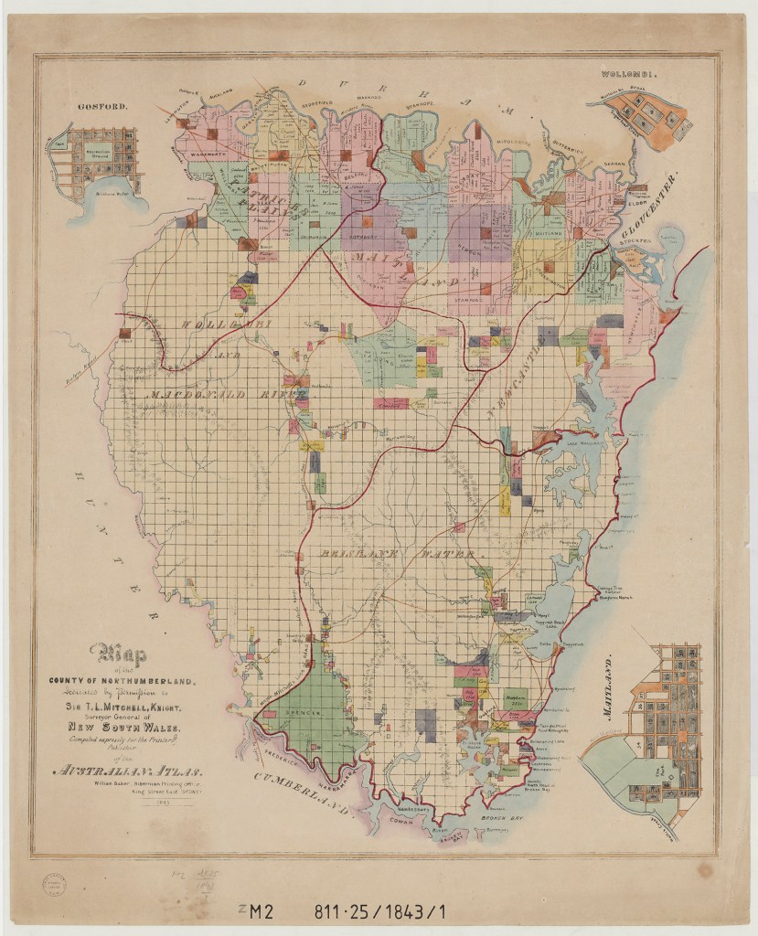
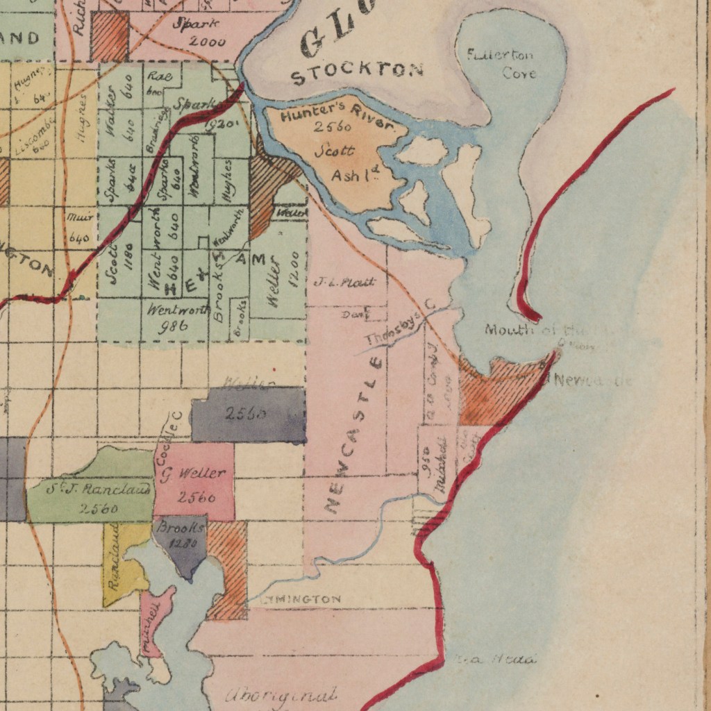
The detail from the large map from 1843 above shows the area of Newcastle marked in pink which John Laurie Platt who was the first settler in this area arriving the area with a Land Grant of 2000 acres granted on 21 August 1822. It was one of the earliest, if not the earliest, grant in the district. In addition to the cultivation of wheat and maize, Platt mined for coal … Platt died on July 17, 1836, and on October 22, 1839, his eldest son sold the land to the Australian Agricultural Company for £6000. 9
George Abner Gray refers to Platt in his journal: Platt and a number of others are now lying in their graves up at the west end of the paddock in a lovely little valie which runs down into a swamp. Platt used to cultivate a deel of land and grow a deel of weat and used to grind the weat with a windmill which was on the hill and he had all the timber cut down for a long range to admit wind to the mill. I could tell a lot of the actions of the Platt’s told me by the old Government men who used to work under him, I have seen their backs which told tales of the leash applied umerserrful.’ 10
‘The Folly’ – Charles Simpson
As seen in the previous chapter, Charles Simpson purchased his first allotment of land at ‘the folly’ on 22 October 1849 and at that time was living at Black Creek which was located not far from New Freugh. He was a colleague of John Crichton Stuart McDouall and other important and influential men in the colony so he would have been well connected. References in newspapers show him working in the Scone, Singleton and Patrick’s Plains Courts until 1851 when it was noted he was ‘leaving the district’ alongside being appointed to the New Commission of Peace. It was in July 1852 that he was appointed the Warden of the Council of Newcastle. Thomas Braye in his recounting of the early history of Waratah recounts: ‘In 1854, with Mr Charles Bolton, another grantee, Simpson, cut up grants on the southern side of what is now Bull-street, and sold it in five-acre blocks. The settlers cultivated it as vineyards and rochards. Among the notable families who settled there was Messrs. Peter Crebert, Philip Kuhn, Crowther, Walters or Waters, Roberts, Russell, Bull Gray and Baker. This settlers could be taken as the first in that area.’ 11
Charles Simpson – Sale of small portions of land at The Folly
The majority of the land owned by Charles Simpson at ‘the folly’ near Platt’s Channel was purchased in 1854 by William Henry Morse, George Phillips Morse and Thomas Tourle, there were however some exemptions. The 1854 indenture record for the sale includes five ‘except and always released out of this release and sale a small portion‘ 12 noted with the date of conveyance as 9th June 1854 to George Gray, Edmund Bull, Philip Kuhn, Benjamin Baker and Peter Crebert.
It may be asked: Why did Charles Simpson choose to sell these very small allotments of three to five acres? This question and other notes on these early settlers on Charles Simpson’s original allotments are found in the chapter ‘Simpson’s Early Settlers’.
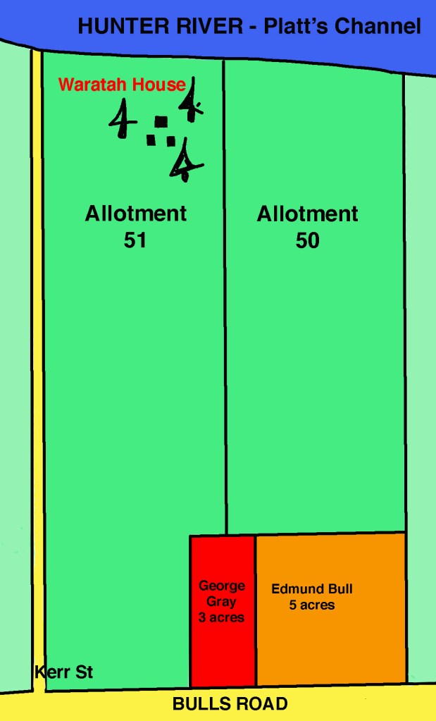
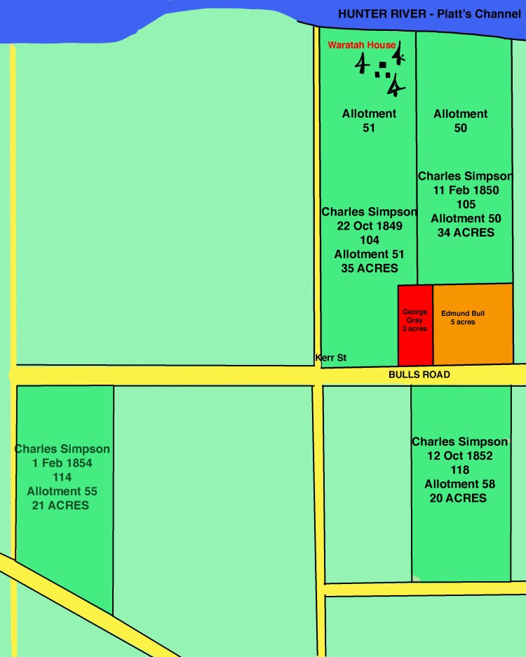
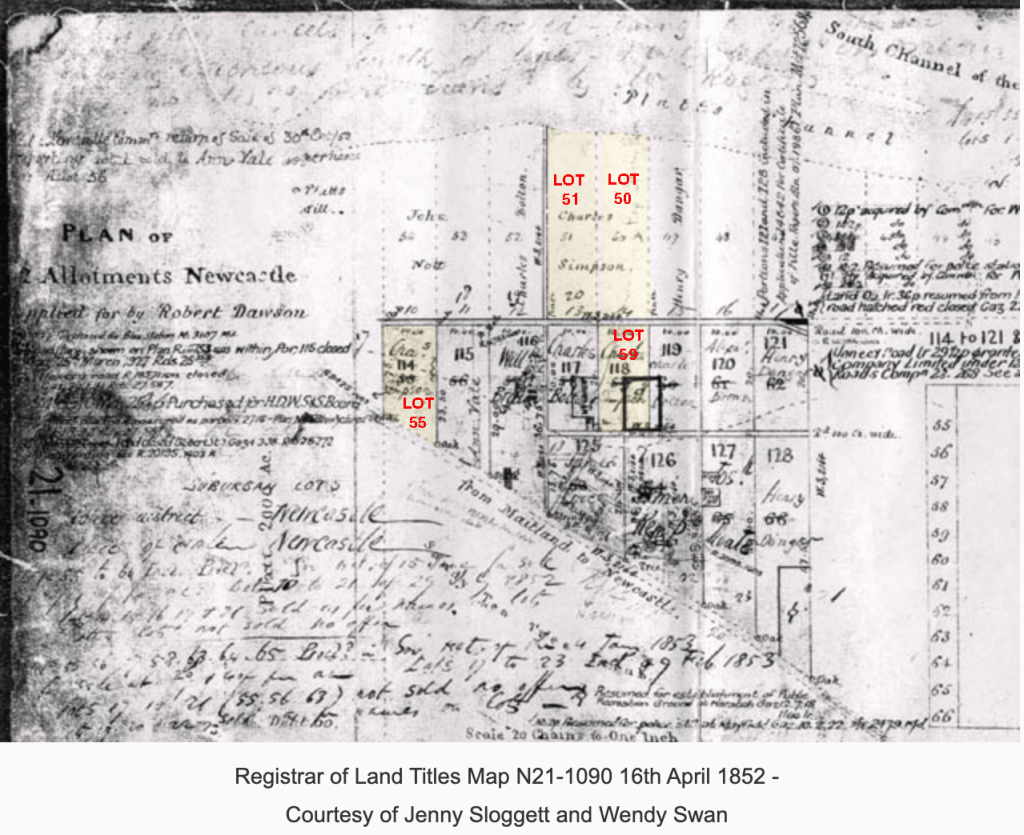
George Gray – 3 acres – portion Land Allotment 50-51
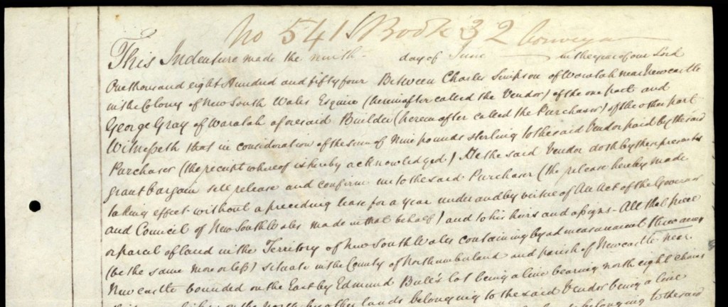
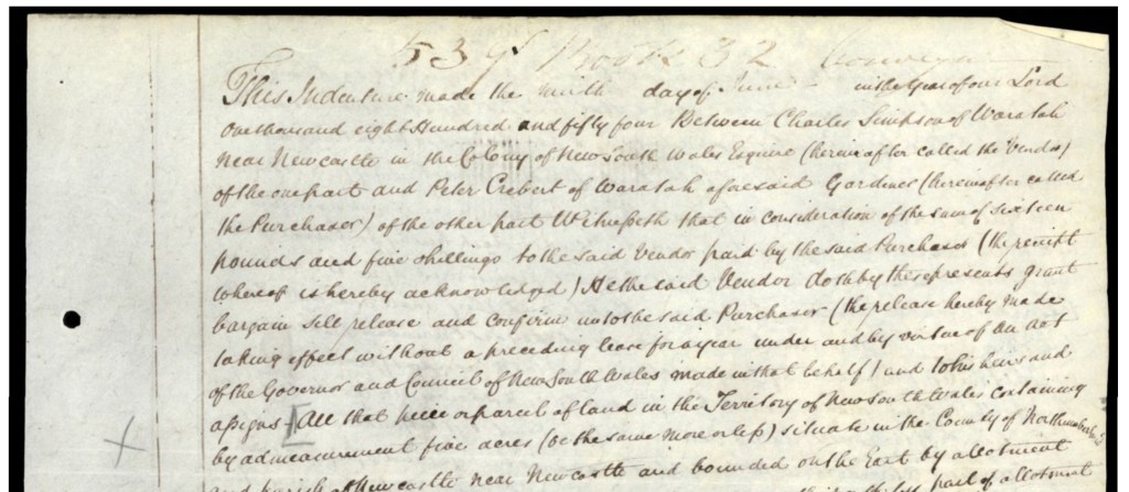
The 9 June 1854 Indenture between Charles SIMPSON and George GRAY for 3 acres of land contained in Book-Number 32-541 states it was ‘Between Charles Simpson of Waratah near Newcastle in the Colony of New South Wales Esquire (hereafter called the Vendor) of the one part and George Gray of Waratah aforesaid Builder‘. That the land was ‘All that piece or parcel of land within the Territory of New South Wales containing by admeasurement three acres (be the same more or less) situate in the County of Northumberland and Parish of Newcastle near Newcastle bounded on the East by Edmund Bull’s lot being a live bearing north eight chains thirty seven links ; on the north by other other lands belonging to the said Vendor being a line bearing west three chains fifty eight links ; on the west by other lands belonging to the said lands being a line bearing South eight chains thirty seven links and on the South by the reserved road being a line bearing last three chains fifty eight links‘. 13
George Gray paid ‘nine pounds sterling’ to Charles Simpson for his 3 acres consisting of small portions of Allotment 50 and 51 as shown below. The witness for the transaction being Benjamin Baker.
Edmund Bull – 7 acres – portion Land Allotment 50
As seen in the map above, the small parcel of 7 acres of land Charles Simpson sold to Edmund Bull was situated within Allotment 50 of the original land grant and adjoined George Gray’s portion.
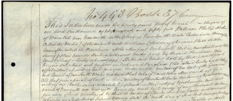
The Indenture is Number 637 Book 35 and is dated 18 December, 1854 between ‘Charles Simpson formerly of Waratah near Newcastle in the Colony of New South Wales but now of Sydney in the said Colony Esquire (therewith after called the Vendor) of the one part and Edmund Bull of Waratah aforesaid Settler (herewith called the Purchaser)’.
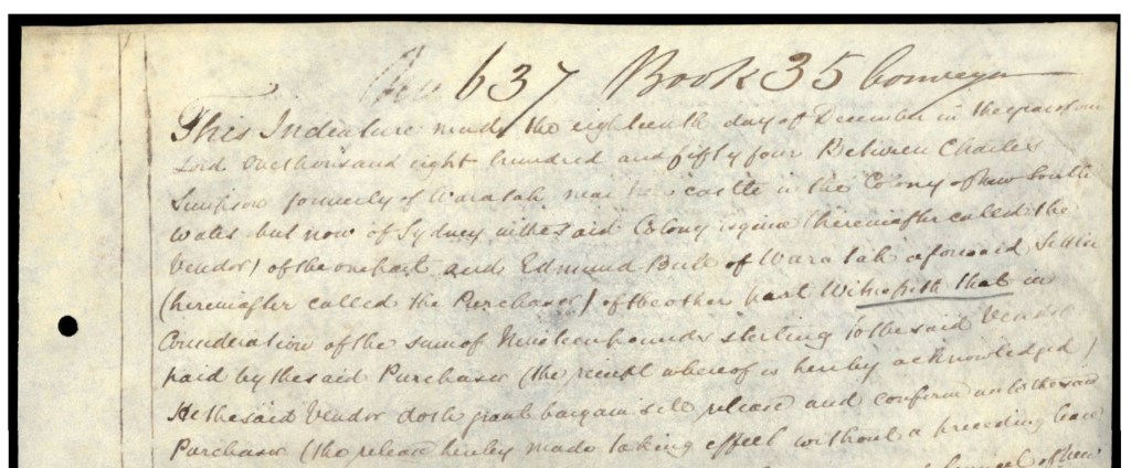
Edmund Bull paid nineteen pounds sterling for his portion of land. Of note within the indenture is the provision of access to water and the river which is included: ‘Together with a right of footway to and from the said seven acres of land … down to the water as enjoyed by the said Purchaser. And also all other ways paths passages waters watercourses lights easements advantages … and profits of deed in the same.’ 14 This would have ensured that Edmund Bull could develop his land and gardens to provide a living for his family. The next chapter will discuss the families of George Gray and Edmund Bull.
Benjamin Baker – 5 acres – portion Land Allotment 59 (118)
A significant purchaser of Charles Simpson’s land was Benjamin Baker who along with George Gray and Edmund Bull were the first settlers at ‘the folly’, Waratah.15
In relation to Charles Simpson’s land at The Folly, the Indenture records dated 9 June 1854, Book-Number 32-542 are ‘Between Charles Simpson of Waratah near Newcastle in the Colony of New South Wales Esquire (hereinafter called the vendor) of Northumberland and Benjamin Baker of Waratah aforesaid Settler’.
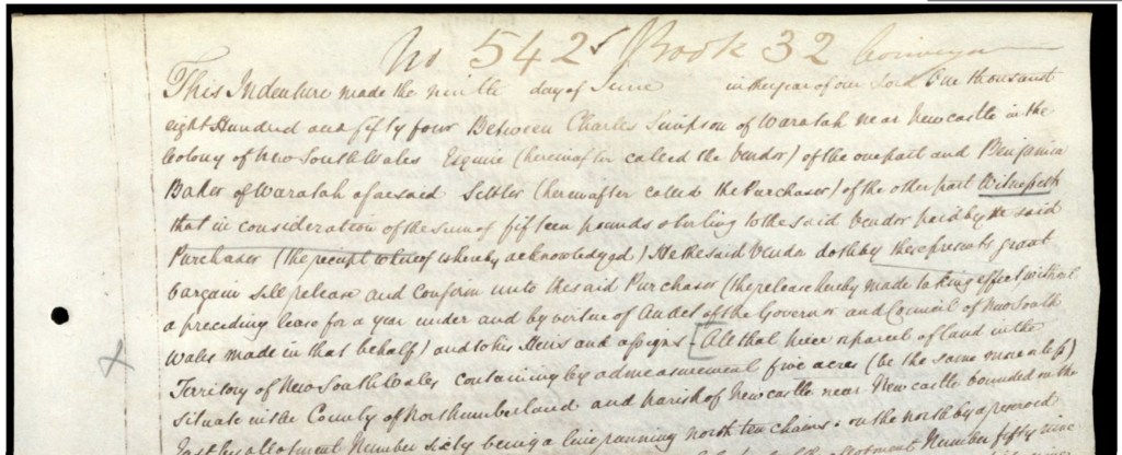
The Indenture also records that Ben Baker paid £15 pounds sterling for five acres ‘as part and parcel of allotment number fifty nine … granted to the said Vendor [Charles Simpson] bearing the date the twelfth day of October one thousand eight hundred and fifty two’.16 In the map below, the small allotment purchased by Ben Baker was within Allotment 58.
Significantly, situated on the land that Ben Baker purchased includes sections that he then sold to anther early settler, William McNulty. McNulty built a stone cottage on his purchased land which went on to be mistakenly attributed to Charles Simpson but should be renamed ‘McNulty’s Cottage’ which is still standing. The story of this land and the cottage are told in the chapter ‘McNulty’s Cottage [Simpson’s]’17
This next map shows Benjamin Baker’s map portion on the right and Philip Kuhn’s allotment on the left. The area later sold to William McNulty can be seen notated.
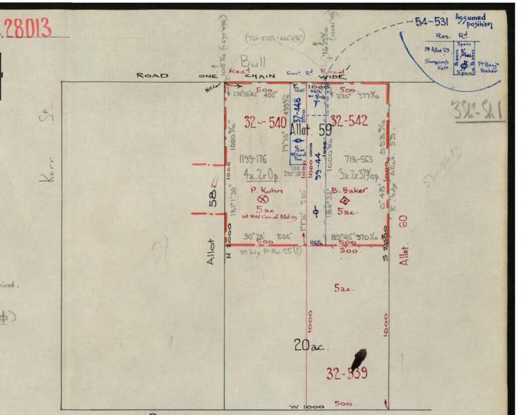
Philip Kuhn – 5 acres – portion Land Allotment 59 (118)
The parcel of land he purchased from Charles Simpson was five acres ‘situated at the north west corner of twenty acres of land allotment fifty nine’ which Charles Simpson had purchased on 12 October 1852.21
Peter Crebert – 5 acres – portion Land Allotment 59 (118)
Peter Crebert purchased his first five acres of land at The Folly, Waratah, from ‘Charles Simpson of Waratah near Newcastle in the Colony of New South Wales Enquire … of the one part and Peter Crebert of Waratah aforesaid Gardener’ on 9 June 1854 like George Gray, Philip Kuhn and Benjamin Baker. Peter Crebert, like Philip Kuhn had fulfilled the 5 years residency and become naturalized enabling the land purchase to be made. Peter Crebert paid ‘the sum of sixteen pounds and five shillings‘ for his five acres ‘of land hereby released are part and parcel of land and situated at the South East corner of twenty acres of land allotment Number fifty nine’. This was land originally purchased by Charles Simpson on 12 October 1852. The witness for the Indenture record was Benjamin Baker. 16
A brief biography of Peter and Maria Louisa Crebert is in the chapter Simpson’s Early Settlers at Waratah
1854 Maps Approximate Land – Allotments 50 – 51 – 59
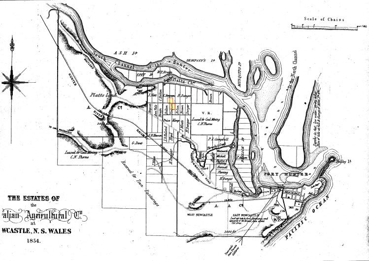
Map: the estates of the Australian Agricultural Company at Newcastle, NSW, 1854 – University of Newcastle LIVING HISTORIES

References
- The Journal of George Abner Gray 1846 – 1941 from the Original Clarence River Historical Society Grafton Second Edition 1975 page 14
- Newcastle Sun Monday 28 March, 1932, Page 4 ‘Waratah 80 years ago’ George Abner Gray
- Newcastle Morning Herald and Miners’ Advocate (NSW : 1876 – 1954), Saturday 3 October 1936, page 5 Waratahs First Settlers Mr. Braye Reviews Early History
- Newcastle Morning Herald and Miners’ Advocate (NSW : 1876 – 1954), Saturday 4 July 1953, page 5 Mayfield Was Too Far to Go Home – Mabel Grieson
- Newcastle Morning Herald and Miners’ Advocate (NSW : 1876 – 1954), Saturday 17 January 1936, page 9 – Looking Back Mayfield Early Days Bull’s Famous Gardens – Sydney Bull
- The Newcastle and Hunter District Historical Society “Waratah and the Original Grants” by T A Braye Read before the society on October 1st 1936 – Hunter Living Histories – Newcastle University
- John Laurio Platt Letter to Governor, Sir Thomas Brisbane Feb. 13th, 1821 – https://uonccmayfield.wordpress.com/pre-1900/platt/
- Australian Dictionary of Biography – Platt, John Laurio by Vivienne Parsons – https://adb.anu.edu.au/biography/platt-john-laurio-2555
- The Newcastle and Hunter District Historical Society “Waratah and the Original Grants” by T A Braye Read before the society on October 1st 1936 – Hunter Living Histories – Newcastle University
- The Journal of George Abner Gray 1846 – 1941 from the Original Clarence River Historical Society Grafton Second Edition 1975 page 14
- Newcastle Morning Herald and Miners’ Advocate (NSW : 1876 – 1954), Saturday 3 October 1936, page 5 Waratahs First Settlers Mr. Braye Reviews Early History
- NSW Land Titles Indenture Record – Book 33 Volume 535 – 17 July 1854 – Between Charles Simpson & William Henry Morse, George Philip Morse of Abington New England & Thomas Tourle
- NSW Land Titles Indenture Record – 1854 – June – Between Charles Simpson and George Gray for Waratah Land Book 32 – Number 541
- NSW Land Titles Indenture Record – 1854 -18 December – Between Charles Simpson and Edmund Bull for Waratah Land Book 35 – Number 637
- The Journal of George Abner Gray 1846 – 1941 from the Original Clarence River Historical Society Grafton Second Edition 1975 page 14 CHECK PAGE!!
- Newcastle Sun Monday 28 March, 1932, Page 4 ‘Waratah 80 years ago’ George Abner Gray
- McNulty’s Cottage – the story of ‘Simpson’s Cottage’ https://georgegraybuilderwaratah.com/2024/08/05/mcnultys-cottage-simpsons/
- NSW Land Titles Indenture Records – 1854 9 June – Peter Crebert & Charles Simpson – Book 32 Number 539
- NSW Land Titles Indenture Record – 1854 9 June – Philip Kuhn & Charles Simpson – Book 32 – Number 540
- NSW Land Titles Indenture Records – 1854 9 June – Peter Crebert & Charles Simpson – Book 32 Number 539
